Property Owner · Sample analysis
417 Kismet St, Carnegie, PA 15106, USA
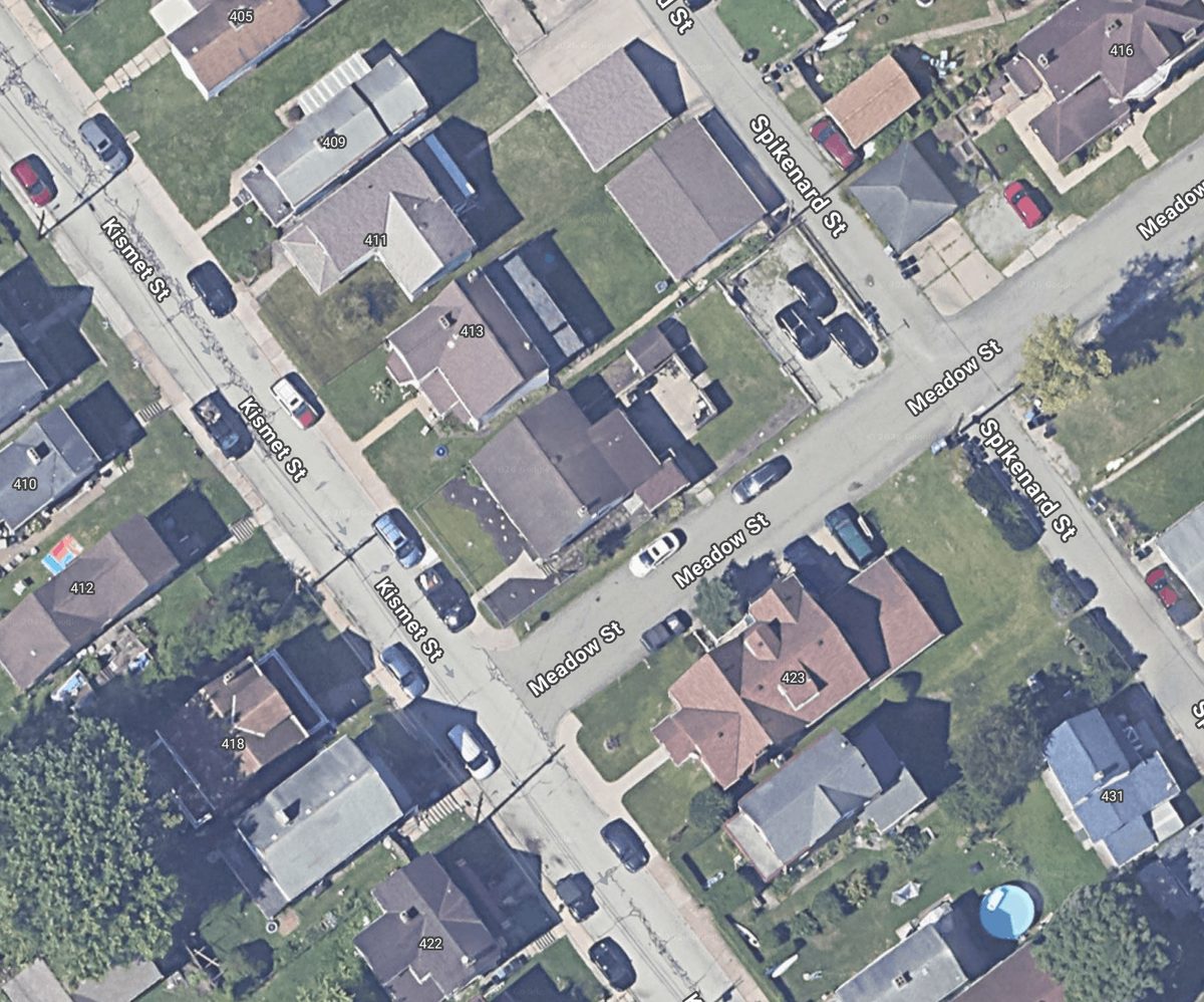
Well-maintained, no red flags this period
The structure is intact and stable, with one rear extension and healthy surroundings. Nothing requires urgent attention; a few items are worth monitoring.
Executive summary
Your property at 417 Kismet St presents as well-kept this period: a uniform roof with no visible damage, a stable footprint, and clean, defined boundaries. The one item to verify is a rear single-storey extension — clearly part of the current footprint but something satellite analysis cannot confirm against permits. Surroundings are healthy, with mature tree canopy along the rear boundary as a seasonal maintenance watch-item. No pool, encroachment, or unauthorised structure was detected.
Change since last pass
Site snapshot
Property scorecard
Key findings
OBSERVED seen in imagery · AI-INFERRED model estimate
Roof intact and uniform
The roof surface is continuous with no visible patching, ponding, or missing sections across the latest pass.
Rear single-storey extension present
A rear addition appears against the older building footprint — worth confirming it matches your permit records.
No pool or unpermitted structures
No swimming pool, large shed, or accessory structure detected on the parcel beyond the extension.
Mature tree canopy on rear boundary
Roughly 18% of the lot is under canopy along the rear line — monitor proximity to the roof and gutters.
Driveway and hardstanding unchanged
No new paving or parking expansion detected versus the prior footprint.
For the owner — what the imagery answers
Each question is scored 0–10 and labelled OBSERVED (seen in imagery) or AI-INFERRED (modelled).
Is the roof in good condition?
8.5/10Yes — the surface is continuous and uniform with no visible patching, ponding, or missing sections in the latest pass.
Are there additions that may need a permit?
7.0/10One rear single-storey extension is present against the older footprint. It cannot be checked against permits from orbit — verify it is on file.
Any boundary or encroachment risk?
8.0/10Parcel boundaries read as defined and respected; no structure or paving appears to cross the line.
Is anything in the surroundings a risk?
7.0/10Mature canopy along the rear boundary (~18% lot cover) is the main watch-item — overhanging limbs near the roof and gutters merit a seasonal check.
Has anything changed since the last look?
8.0/10Aside from the extension already in the footprint, no new structures, paving, or pool were detected versus the prior pass.
What it protects
The two issues that most often surprise owners at sale or refinancing are an unpermitted addition and undetected roof decline. Catching either early — the extension is flagged here for permit-check, and the roof reads clean — can protect anywhere from a few thousand dollars in repairs to a stalled closing worth far more.
Recommended actions
- NowConfirm the rear extension's permit
Check the rear addition is recorded with the municipality — unpermitted additions are the most common surprise at sale or refinancing.
- SoonTrim canopy near the roofline
Schedule a seasonal trim of overhanging limbs along the rear boundary to protect the roof and gutters.
- MonitorKeep monthly oversight
Continuous monitoring will flag roof decline, a neighbour's encroachment, or new nearby construction the week it appears.
Solar & energy intelligence
Roof-plane geometry and modelled annual irradiance for this address (illustrative).
The main roof planes face south and south-west with a favourable pitch, giving this property solid rooftop-solar potential. After accounting for the rear tree canopy, modelled annual output is on the order of 8,300 kWh — enough to offset a large share of a typical household's electricity use.
The single limiting factor is afternoon shading from the mature canopy along the rear boundary. Trimming (already flagged as a maintenance item) would recover part of the ~9% modelled shading loss. Figures are modelled from overhead geometry and typical regional irradiance, not an engineering solar survey.
Vegetation & canopy health (NDVI)
Relative greenness/vigour of on-lot vegetation from multispectral analysis. 0 = bare, 1 = dense healthy growth.
On-lot vegetation reads as healthy this period, with a mean NDVI of 0.61 and no drought- or disease-stress zones detected. Tree canopy has expanded modestly (+3%) over the past year — good for shade and privacy, but reinforcing the rear-roofline trim recommendation.
NDVI is tracked pass-over-pass so a live account is alerted early to browning lawns, dying trees near structures, or vegetation encroaching on the roof — issues that are cheap to fix early and costly to ignore.
Sustainability & ESG profile
The parcel balances built and green cover reasonably well: roughly a third is impervious (roof, driveway, hardstanding) against ~18% tree canopy. Adding rooftop solar and retaining canopy would materially improve the property's environmental profile and its appeal to sustainability-minded buyers.
These indicators feed the optional ESG / green-scoring section that lenders and some insurers increasingly ask about.
Environmental & climate risk
Location-based hazard exposure from public geospatial layers (indicative, not a certified hazard determination).
No high-severity environmental hazard was identified for this address. The one moderate item is vegetation proximity: the rear canopy sits close to the structure, so keeping a clear, maintained gap protects against both fire spread and storm-limb damage.
Risk layers are refreshed over time, so a live report flags changes — a new floodplain remap, a neighbouring lot clearing, or drought conditions raising fire risk.
Insurance readiness
Signals that commonly affect home-insurance underwriting and premiums.
From an underwriting standpoint the property presents favourably: an intact, simple roof and no high-liability features (pool, trampoline) detected. The one item that can affect a policy is the rear extension — insurers and buyers alike expect additions to be permitted, so confirming it on file protects both coverage and resale.
A dated, independent roof-and-structure read is exactly what carriers ask for at renewal or claim time; continuous monitoring keeps that evidence current.
Legal & administrative intelligence
Satellite analysis places the current footprint — including the rear extension — clearly within the parcel boundaries, with no visible encroachment onto or from neighbouring lots. What imagery cannot see is the paperwork: whether the extension was permitted, and whether any easements or setbacks apply.
The recommended checks are inexpensive and worth doing once: confirm the rear addition against municipal permit records, and verify no utility or access easement crosses the built area. Both are the kind of thing that only becomes a problem at sale or refinance — when it is most expensive to discover.
Neighbourhood & market context
The immediate surroundings read as a stable, gently improving street: several neighbours have replaced roofs and added pools in the past year, and one construction site sits two lots away — worth monitoring for noise, access, and any boundary or drainage impact during the build.
For an owner, neighbourhood change is a leading indicator of value. A live account surfaces new nearby construction, teardowns, or land-use changes as they appear, not at the next drive-by appraisal.
Roof deep-dive & replacement forecast
Roof-plane condition read from the latest high-resolution pass (illustrative; not an inspection).
The roof reads as a simple gable in good condition: continuous, uniform surfaces with no visible patching, granule-loss streaking, ponding, or displaced sections across the latest pass. Vents and flashing penetrations appear intact, and there is no thermal or tonal anomaly suggesting moisture ingress.
On this evidence the roof is mid-life with no near-term replacement pressure; the practical horizon is a routine inspection, not a re-roof. Because roof condition is the single biggest driver of both maintenance cost and buyer confidence, PropOrbit tracks it pass-over-pass and flags the first signs of decline — years before they become a leak.
Structure, height & 3D model
Dimensional read from overhead geometry and a surface-height model (estimates).
A digital surface model turns the imagery into a lightweight 3D read of the property: ridge height around 6.2 m, a ground footprint near 210 m², and a rear single-storey extension that sits cleanly against the original massing. Nothing in the geometry suggests structural movement, sag, or an unstable roofline.
The 3D read underpins the solar, shading and drainage sections and, for a live account, lets change be measured volumetrically — a new structure, a demolished outbuilding, or a raised roof shows up as a height change, not just a difference in the picture.
Sun & shade atlas
Modelled solar exposure across the roof and lot by season (indicative).
Across the year the south and south-west roof planes enjoy long, largely unobstructed exposure — over nine hours a day in summer. The main modifier is the mature rear canopy, which throws afternoon shade onto the rear roof and garden and is the chief limiter on both solar yield and lawn vigour behind the house.
The atlas is what makes the solar, garden and vegetation reads consistent: the same shading that trims panel output is the shade that keeps the rear lawn cooler and the reason a seasonal canopy trim keeps paying off.
Water efficiency & drainage
Surface-water behaviour inferred from grading, impervious cover and outfalls (indicative).
Site grading appears to move water away from the structure, and no standing-water or chronic-damp signatures were detected around the foundation line — a good baseline for a property with the rear canopy dropping leaf litter into gutters each autumn. Roughly a third of the parcel is impervious, so most rainfall becomes managed runoff rather than infiltration.
Drainage is a slow, expensive problem when it goes wrong. Monitoring catches the early signatures — a new low spot holding water, a blocked outfall, or grading disturbed by nearby construction — while they are still a gutter-and-shovel fix.
Ecosystem services & carbon
The on-lot trees do measurable work: an estimated 2–3°C of local cooling in summer, meaningful rainfall interception, and modest annual carbon sequestration. For an owner this is comfort and lower cooling load; for the neighbourhood it is stormwater and heat-island relief.
These figures feed the optional ESG / green-value section and are increasingly relevant to sustainability-minded buyers and to lenders offering green-linked terms.
Garden & landscape ROI
Frontage reads as tidy and well-kept, with a maintained lawn and clean hardscape — the curb-appeal signals that carry disproportionate weight at sale. Mature planting adds character and privacy without looking overgrown.
The main ongoing return-on-effort item is the rear canopy: trimming protects the roof and recovers solar yield, while retaining the trees preserves shade, privacy and the environmental profile. Figures are illustrative, not an appraisal.
Perimeter & access security
The parcel has well-defined boundaries and a clear, overlooked frontage — both good passive-security signals. The lower-scoring aspect is the rear: the mature canopy that provides privacy also reduces natural surveillance along the back boundary, the most common approach for opportunistic access.
None of this indicates a problem; it points to where light and monitoring pay off most. For portfolio and higher-value accounts, the same read scales into a per-site security posture.
Proximity, services & access
Distances to key services and infrastructure from public geospatial data (approximate).
The address sits in a convenient but quiet position: schools, transit and an arterial road are all within a short distance, while the property itself is on a low-traffic residential street. Emergency-service proximity is typical for the area and is one of the quieter drivers of both insurability and resale.
Access and proximity rarely change — but when they do (a new road, a school opening, a transit extension) the effect on value is large, and continuous monitoring surfaces the groundworks early.
Surveillance & monitoring design
Suggested physical-monitoring layout derived from the site read (advisory).
If the owner wants on-site coverage, the imagery points to an efficient layout: prioritise the driveway approach and the shaded rear boundary, where natural surveillance is weakest, with two motion zones covering the likely access lines. No existing cameras were detected from overhead.
This complements — rather than replaces — orbital monitoring: cameras watch the moment, PropOrbit watches the property's condition and surroundings over months.
Composite security index
Rolling the security reads into one index, the property scores well: a sound structure, a defined perimeter, and a calm setting, with the shaded rear boundary the single soft spot. The index is designed to be tracked over time so a deterioration — a downed fence, cleared cover, or new access — moves the number and triggers an alert.
Market valuation context
Directional value drivers from the analysis (illustrative — not an appraisal or CMA).
Pulling the drivers together, the property points modestly upward in value terms: a clean roof and maintained lot are positives, area momentum is stable-to-rising, and the only drag is the unverified rear extension — a paperwork item, not a physical defect. Resolving it removes the one discount a careful buyer or lender would apply.
This is directional context, not a valuation. A live account pairs it with dated evidence, so when it is time to sell or refinance the condition story is already documented.
12-month maintenance forecast
Indicative upkeep calendar from the condition read (illustrative ranges, not quotes).
Nothing here is urgent. The near-term calendar is light: confirm the extension's permit now, clean gutters and trim the rear canopy before winter, and book a routine roof inspection in spring. None of it is structural; all of it protects the clean baseline this report establishes.
The one item to simply keep on the horizon is an eventual roof reserve — a decade-plus away on current condition, but worth earmarking so it is a planned expense, never a surprise.
Change-detection history
Illustrative pass-over-pass timeline; a live account accumulates real dated history.
The value of monitoring is the timeline it builds. On an illustrative history the only material event in two years is the rear extension appearing about a year ago; everything else is stability, which is exactly what an owner wants to be able to prove. Each pass is dated and archived.
Over time this becomes the property's evidence file — a defensible, timestamped record of condition and change that pays for itself at the one moment paperwork matters most: a sale, a claim, or a refinance.
Thermal envelope & energy efficiency
Building-envelope efficiency signals inferred from roof, geometry and setting (indicative).
The building's simple, compact form is inherently efficient — less exposed surface per unit of floor area — but the standard dark roof runs warm in summer and points to attic heat gain. Rear and west-side canopy shade offsets part of that load in the afternoon.
The two highest-return efficiency moves the read suggests are attic insulation and, at the next re-roof, a lighter/cool-roof surface — both of which also lift the property's ESG and resale profile. These are inferred signals, not an energy audit.
Boundary & encroachment survey
Parcel-line read against the visible footprint (indicative; not a legal survey).
Every visible structure — house, extension, driveway — reads as sitting within the parcel, and the rear boundary is fenced and clearly defined. No structure or paving appears to cross the line in either direction, and neighbouring built elements respect their setbacks.
The one physical item to keep an eye on is the rear canopy overhanging the boundary, a common source of neighbour disputes over limbs and leaf litter. Anything that satellite geometry cannot settle — the legal line itself — is a records check, flagged in the legal section.
Neighbourhood transactions & comparables
Illustrative comparable activity within ~500 m (demonstration data).
The immediate area shows healthy, steady turnover: several comparable homes have transacted in the past year, days-on-market appear to be shortening, and owners are investing (new roofs and pools) rather than deferring — all signals of a stable-to-improving micro-market.
For an owner, comparables are the frame for every value decision. A live account keeps this current from imagery-visible signals — new construction, renovations, and land-use change — between formal valuations.
Renovation & development potential
Feasibility signals for future works from lot geometry (indicative, subject to zoning).
The lot has moderate undeveloped area, most of it to the rear, which is the plausible zone for a garden room or accessory dwelling subject to local zoning and the existing extension. Front and side headroom for further building looks limited, but parking and hardstanding could be expanded, and the roof is well suited to a solar retrofit.
The binding constraints are the rear canopy and setback rules rather than the structure itself. This section is a feasibility signal to guide a professional feasibility check, not planning advice.
Rooftop solar financial model
Indicative economics for the modelled 6.4 kWp system (illustrative, not a quote).
On the modelled 6.4 kWp system, indicative economics are attractive for an owner-occupier: roughly 8,300 kWh a year, over half of it usable on-site, with a payback window in the high-single-digit years before incentives and a positive lifetime return. Trimming the rear canopy recovers part of the ~9% shading drag and shortens payback.
These figures are modelled from geometry and typical regional irradiance and tariffs — directional, not a solar quote. They exist to show whether a formal quote is worth pursuing; here, it is.
Air, noise & environmental quality
Setting-based environmental amenity signals (indicative, from public context).
The property sits in a quiet residential pocket set back from the nearest arterial, with moderate-to-good green cover and no industrial land use nearby — a favourable amenity setting for both liveability and resale. Noise and traffic exposure read as low.
Environmental amenity is easy to overlook and hard to change, which is exactly why it supports value steadily. Monitoring flags the exceptions: a new road, a commercial rezoning, or loss of nearby green space.
Accessibility & mobility
How well-connected the address is for daily movement (approximate).
Day-to-day connectivity is strong without the downsides of a busy road: transit, schools and an arterial are all a short walk or drive away, while the home itself keeps a quiet frontage and off-street parking. That balance — convenient but calm — is one buyers pay for and rarely find together.
Mobility factors move slowly but decisively; a live account surfaces the leading indicators (roadworks, transit projects) as they break ground.
Parcel & ownership records checklist
The off-imagery items worth confirming once, in your records.
Satellite analysis settles the physical questions; a short records checklist settles the paper ones. The priority items for this property are the rear extension's permit and confirming no easement crosses the built area — both cheap to check now and expensive to discover at closing.
None of these are red flags; they are the routine confirmations that turn a good imagery read into a clean, sale-ready file. This is a checklist, not legal advice.
Certification & analyst notes
This sample is a demonstration of the live report's structure and depth. In a paid account each section is generated from dated, licensed sub-metre passes for the specific address, the scores are computed rather than illustrative, and the findings carry per-item confidence and imagery dates.
Report #PO-SAMPLE-ASS · generated from a single reference frame · PropOrbit orbital intelligence. Findings are decision-support, not a survey, appraisal, engineering assessment, or legal advice.
Future scenario & monitoring plan
Left unmonitored, the two most likely value events for this property over the next 12–24 months are gradual roof wear and change on adjacent lots. Neither is visible day-to-day, and both are cheapest to address the moment they start.
Your monitoring plan: monthly passes tracking roof condition, footprint, canopy and boundary; automatic alerts on any material change; and a refreshed score each period. The goal is simple — you learn about anything that moves your property's value the week it happens, with a dated image to prove it.
Property Owner analysis
Your property at 417 Kismet St presents as well-kept this period. The roofline reads as uniform with no signs of damage or repair scarring, which is the single biggest driver of both maintenance cost and resale confidence — a good position to be in.
The one item to verify is the rear extension. From orbit it is clearly part of the current footprint, but satellite analysis cannot see permits. If you built or inherited it, confirm it is on file with the municipality; unpermitted additions are the most common surprise at sale or refinancing.
On surroundings, the mature canopy along the rear boundary is an asset for shade and privacy but a maintenance watch-item: overhanging limbs near the roof and gutters are worth a seasonal check. No pool, encroachment, or unauthorised structure was detected.
Bottom line: nothing here demands urgent action. Continuous monitoring will flag the things that actually change value — roof degradation, a neighbour's encroachment, new construction next door — the week they appear, not months later at your next inspection.
The full report · 21 sections
This sample demonstrates 20 of the 21 sections your live report includes. Highlighted rows are shown above; the rest are generated for paying accounts.
- 01Executive summaryin this sample
- 02Annotated imageryin this sample
- 03Market & location datain this sample
- 04Technical metricsin this sample
- 05Certification & contactin this sample
- 06Solar intelligencein this sample
- 07Sustainability / ESGin this sample
- 08Vegetation health (NDVI)in this sample
- 09Sun & shade atlasin this sample
- 10Water efficiencyin this sample
- 11Ecosystem servicesin this sample
- 12Garden ROIin this sample
- 13Perimeter securityin this sample
- 14Proximity securityin this sample
- 15Environmental riskin this sample
- 16Surveillance intelligencein this sample
- 17Security indexin this sample
- 18Future scenario
- 19Digital twin & 3Din this sample
- 20Legal / admin intelligencein this sample
- 21Social / demographic profilein this sample
Methodology & data sources
This sample is built from a single high-resolution reference frame with an illustrative analysis overlay. Production reports combine dated satellite passes with public address data, comparing roof condition, footprint and surroundings pass-over-pass. Measurements are estimates from overhead geometry; this is not a survey, appraisal, or legal advice.
Want this for your property?
Enter any address or coordinates — your report lands in your inbox and dashboard.
Sample / demonstration report. Findings are illustrative and not a survey, appraisal, or legal advice. © PropOrbit.